Encyclopedia - أنسكلوبيديا
موسوعة تاريخ أقباط مصر - Coptic history
بقلم المؤرخ / عزت اندراوس
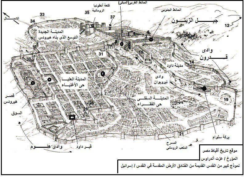
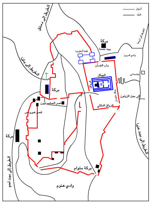
نموذج لخريطة أورشليم التى بناها هيرودس وصلب المسيح خارج اسوارها
|
موسوعة تاريخ أقباط مصر - Coptic history بقلم المؤرخ / عزت اندراوس نموذج لخريطة أورشليم التى بناها هيرودس وصلب المسيح خارج اسوارها |
إذا كنت تريد أن تطلع على المزيد أو أن تعد بحثا اذهب إلى صفحة الفهرس تفاصيل كاملة لباقى الموضوعات أنقر هنا على دليل صفحات الفهارس فى الموقع http://www.coptichistory.org/new_page_1994.htm |
Jerusalem At the Time of Jesus |
 |
 (2) |
2. Southern Wall and Royal Stoa
7. The location of the Western Wall (Wailing Wall)
11. The Mount of Olives
13. The Kidron Valley (as it appears today)
15. City of David (Mt. Ophel)
17. The Pool of Siloam
18. The Tyropoean Valley وادى تيروبوان
20. Lower City (Poor section)
23. Upper City (Wealthy section)
24. David's Tomb
27. The Theater
28. The Market Place
29. Herod's Palace
36. Antonia Fortress (NT - Castle)
Guided tour of ancient Jerusalem.
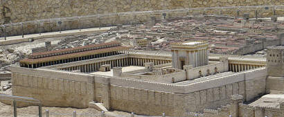
1. The Herodian Temple Mount
(Mt. of Olives) (Model, Holy Land Hotel, Jerusalem.)
2. The Herodian Temple Mount
The Temple Mount looking southwest. (Model, Holy Land Hotel, Jerusalem.)
3. Mt. Ophel
Ariel view of the modern location of the City of David (Ophel) - Looking from South to North. The white broken-line is where the ancient city of David was located (which is outside the city wall today). The gold domed building is the Muslim shrine called the Dome of the Rock. It is surrounded by ancient retaining wall of the Herodian Temple mount. This picture gives distance perspective. The Kidron valley can be seen on the left side.
4. Aerial view of Temple Mount
Aerial view of the Harem-esh-Sharif (Dome of the Rock and the Al-aksa mosque). The wall is the retaining wall left over from the Herodian Temple mount.
5. Painting of Herodian Temple Mount
The temple mount looking for southwest to northeast. This view shows various entryways into the temple. The southern entrance was the most frequently used by commoners. The Temple was surround by a series of courts. Immediately surrounding the Temple was the court of the priests (smoke can be seen rising from the altar of sacrifice in the court of the priests). The court of the women was a large square court to the east and front of the Temple. The large court surrounding the Temple and its immediate courts was known as the court of the gentiles. A balustrade separated the court of the gentiles from the Temple and its surrounding courts. Non-Jews could not pass the balustrade. It was in the court of the gentiles that money changers and animals were sold. Thus, this was the place of the Savior's cleansing of the temple (Matt. 21:12-13; Mark 11:15-19; Luke 19:41-48; John 2:13-17). (Peter Connolly, Living in the Time of Jesus of Nazareth.)
6. A cutaway look at the Temple Mount
The dark blue walls represent the retaining walls built by Herod. The lighter blue walls located within the Herodian walls represent retaining walls from earlier time periods. The center square light blue walls represent the retaining walls built by Solomon. The southern extension (over taking the Akra) was built by the Hasmoneans about 186 B. C. (Leen and Kathleen Ritmeyer, Secrets of Jerusalem's Temple Mount).
7. The southern wall of the Temple Mount
Southern retaining wall of the Herodian Temple mount. The stairs led up to the court of the gentiles. The red-roofed basilica is called the Royal Stoa. (Model, Holy Land Hotel, Jerusalem)
8. Southwest corner of the Temple Mount retaining wall
Actual stones of the pinnacle of the Temple.
9. Painting - southwest corner of Temple Mount
Painting of the south-west corner of the temple mount as it would have appeared during the time of Christ. (Peter Connolly, Living in the Time of Jesus of Nazareth)
10. Place for the trumpeter
Inscribed stone the fell from top corner of the temple mount during the Roman destruction of Jerusalem (70 AD). The Hebrew reads, "To the place (lit. house) of the trumpeting for . . . " (last part missing). It appears that this was the place designated for a priest to blow the horn announcing the beginning and end of the Sabbath. (Hershel Shanks, Jerusalem: An Archaeological Biography, p. 157)
11. Southern stairs
Stairs leading up to the gates through which temple participants passed to ascend the stairs to the temple mount (court of the gentiles). The Psalmist asked, "Who shall ascend into the hill of the LORD? or who shall stand in his holy place?" He answered, "He that hath clean hands, and a pure heart" (Psalms 24:3-4). (Model, Holy Land Hotel, Jerusalem)
12. Archaeological findings of southern stairs
Archaeological excavations of the southern wall of the temple mount.
13. Stairways in court of the gentiles
The stairs from the southern wall exit through the two gates into the court of the gentiles. The court of the gentiles is surrounded by a pillared courts. The red-roofed structure is called the Royal Stoa. The Sanhedrin (Jewish ruling court) met in this location. (Model, Holy Land Hotel, Jerusalem)
14. Cross section of the Royal Stoa
The Royal Stoa was a basilica with an apse at its eastern end. The Sanhedrin met at the apse in the eastern end. The pillars stood over 30 feet in height. (Hershel Shanks, Jerusalem: An Archaeological Biography, p. 157)
15. Sanhedrin
A meeting of the Sanhedrin in the Royal Stoa. (Miriam Feinberg Vamosh, Daily Life at the time of Jesus, p. 28)
16. Courtyards around the Temple
Temple and surrounding walls enclosing the court of the women (treasury). Around the stairs leading up into the court of the women is a balustrade. Non-Jews were not allowed to pass beyond the balustrade. (Model, Holy Land Hotel, Jerusalem)
17. The Temple and the inner courts
The forecourt is the court of the women (treasury). It was here that the woman taken in adultery was brought before the Savior (John 8). The court directly surrounding the Temple is the court of the priests. (Model, Holy Land Hotel, Jerusalem)
18. Close up of the Temple
A close up of the Temple. The half-moon stair led up to the Nicanor Gate. Immediately behind the Nicanor Gate is the narrow court of the men (between the pillars). Behind the court of the men and immediately surrounding the Temple is the court of the priests. Part of the altar of sacrifice can be seen. (Model, Holy Land Hotel, Jerusalem)
19Ariel view of the modern location of the City of David (Ophel) - Looking from South to North. The white broken-line is where the ancient city of David was located (which is outside the city wall today). The gold domed building is the Muslim shrine called the Dome of the Rock. It is surrounded by ancient retaining wall of the Herodian Temple mount. This picture gives distance perspective. The Kidron valley can be seen on the left side.
The Antonia Fortress (often called "castle" in the New Testament) was located on the northwest corner of the Temple Mount. There were stairs leading from the fortress into the court of the gentiles. Paul was taken captive by the Roman guard and led into the fortress up the stairs. Receiving permision from the Roman guard, he spoke to the Jews who were in the court of the gentiles from the stairs. (See Acts 21-21) (Model, Holy Land Hotel, Jerusalem)
20. Pools of Bethesda and Antonia Fortress
Pools of Bethesda in the foreground. It was here that the Savior healed an invalid on the Sabbath, leading to a negative encounter with the Jewish leaders (John 5). The Antonia Fortress (castle) is the background. The Antonia fortress was the Roman garrison and a possible place where Christ was taken for trial before Pilate. (Model, Holy Land Hotel, Jerusalem)
21. Upper city
The upper city of Jerusalem where the wealthy elite lived. (Model, Holy Land Hotel, Jerusalem)
22. Upper city aerial view
Herod's palace in the foreground. Directly east is the market place. Theater can be seen in the upper part of the picture. David's Tomb (the pyramid topped building). The Hippodrome (chariot racing) can be seen in the upper left (Actually the Hippodrome was located outside the walls of the city). (Model, Holy Land Hotel, Jerusalem)
23. Aerial view of Upper City and New City
An aerial view of the Upper City (left) and the New City (right). Temple can be seen in the upper part of picture. (Model, Holy Land Hotel, Jerusalem)
24. Herod's Palace.
Herod's Palace was located in the Upper City. The wise men would have visited Herod in this place (Matt. 2). This may also be the place that Pilate sent the Savior to in order to be interrogated by Herod Antipas (the son of Herod the Great) during the last week of the Savior's life (Luke 23:6-12). This picture also shows the market place just out the gate from Herod's palace. Also the theater on the left of the picture and David's tomb - the pyramid topped structure on the right of the picture. (Model, Holy Land Hotel, Jerusalem)
25. Herod's Palace - Aerial View
An aerial view of Herod's palace with the market place in the upper part of the picture. (Model, Holy Land Hotel, Jerusalem)
26. Herod's palace to Antonia Fortress
Herod's palace in the foreground. The Antonia Fortress (four towered structure) in the upper left hand corner. These are the two possible sites of the Savior's trial before Pilate and Herod Antipas. (Model, Holy Land Hotel, Jerusalem)
27. The Theater
The Theater was located in the Upper City. (Model, Holy Land Hotel, Jerusalem)
28. David's Tomb
A view of the Upper City (wealthy section). David's Tomb - the pyramid topped structure is in the foreground. This figures in a discourse given by Peter (see Acts 2:29). It was probably in this area that the "upper room" where the Savior held the last supper was located. The Temple Mount and the Antonia Fortress are on the horizon. (Model, Holy Land Hotel, Jerusalem)
29. Painting of Temple from the traditional location of the Upper Room
["From the Rooftop of the Last Supper" by Al Rounds (Ensign, Jan. 1995)]
30. Lower city
The poor section of Jerusalem. Again, the section of city in the foreground was not built until after the time of Christ. The northern wall of the city at the time of Christ can be seen in the upper left. The two traditional sites of Golgotha can be seen in this photo. The first can be seen in the middle right just outside a small gate in the wall. The other is more difficult to spot. Out the Damascus Gate and up the road to the right can be seen a clearing. In that clearing is a hill that some claim to be Golgotha. (Model, Holy Land Hotel, Jerusalem)
31. Jerusalem from the north
This is a view of Jerusalem looking southeast. This shows a section of Jerusalem built after the time of Christ but before the Roman destruction in 70 AD. The northern wall of the city as it was at the time of Christ can be seen in the upper left. A gate can be seen in that wall with the Atonia Fortress behind and to the left. This gate is the Damascus Gate. (Model, Holy Land Hotel, Jerusalem)
32. The New City
The section of city in the foreground was not built until after the time of Christ. The wall in the upper part of the picture likewise did not exist at the time of Christ. The wall immediately surrounding the northern part of Antonia Fortress enclosed the New City, a section of the city that existed at the time of Christ. The two traditional sites of Golgotha can be seen in this photo. The first can be seen in the middle right just outside a small gate in the wall. The other is more difficult to spot. Out the Damascus Gate and up the road to the right can be seen a clearing. In that clearing is a hill that some claim to be Golgotha. (Model, Holy Land Hotel, Jerusalem)
33. Golgotha - Traditional
One of the traditional Golgotha's (the Church of the Holy Sepulcher stands over this site today) is seen in the lower left hand corner.
34. Tyropoean Valley
The Tyropoean valley. The Pool of Siloam is in the foreground. The temple mount can be seen on the horizon. The City of David (Ophel) is the walled city on the right. The poor section is to the left. The Pool of Siloam played a major role in the Feast of Tabernacles and was the place where the miracle of the man born blind washed his eyes and came out seeing (John 9). (Model, Holy Land Hotel, Jerusalem)
This site was last updated 10/30/18